The Lewis and Clark Expedition
Lewis and Clark Expedition
SUMMARY
The Lewis and Clark Expedition (1804–1806) was a federally funded venture to explore the North American West. The expedition’s principal objective was to survey the Missouri and Columbia rivers, locating routes that would connect the continental interior to the Pacific Ocean. The Louisiana Purchase of 1803, in which the United States acquired some 828,000 square miles of land west of the Mississippi River, facilitated the mission, allowing the explorers unprecedented access to land that had previously been owned by Spain and then France. President Thomas Jefferson invested his time, energy, and political capital into this project and took direct charge of its initial planning and organization. The expedition is named for its commanders, Meriwether Lewis and William Clark. Under their leadership the group of thirty-three, known as the Corps of Discovery, succeeded in reaching the Pacific and returning safely despite considerable challenges, ranging from navigating unfamiliar terrain to maintaining good relations with the numerous Indian tribes that lived in the Louisiana Territory. Along the way, the expedition gathered invaluable scientific, ethnographic, and cartographic information, creating a detailed written record of the journey in a series of journals.
The Lewis and Clark Expedition emerged from the confluence of scientific, economic, and diplomatic concerns. From the moment Europeans arrived in the Americas, they had sought to survey the land. But these efforts assumed a new character in the eighteenth century, as principles of Enlightenment science inspired contingents on both sides of the Atlantic to endorse new efforts to explore western North America. Thomas Jefferson was an active member of this group, but he became equally fascinated with the economic benefits that might come from western exploration. Jefferson was particularly eager to see the United States join in the lucrative western fur trade. He also believed that western exploration might provide vital intelligence on the nation’s principal rivals for dominance of North America: Britain, which controlled Canada and through the fur trade was extending its reach to the United States; France, which no longer had territorial possessions in North America but wielded considerable influence through its connections with French fur traders and Indian suppliers; Spain, which claimed all of the territory west of the Mississippi and south of Canada; and the Indian groups that remained the real governing power in much of the trans-Mississippi West and the Missouri valley.
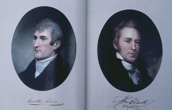
During the last quarter of the eighteenth century, Jefferson had tried to launch a variety of western expeditions without success. He focused on locating the Northwest Passage, the fabled water route that connected the Mississippi River to the Pacific Ocean, which he believed might lie at the confluence of the Missouri and Columbia rivers. When Jefferson became president of the United States in 1801, he finally had both the political power and the institutional resources to convert his plans into reality. With a small budget allocated by Congress, Jefferson directed the initial planning for the expedition. He quickly selected Meriwether Lewis, a captain in the U.S. Army and his private secretary at the time, to serve as commander of the expedition. Lewis in turn selected William Clark to lead the expedition with him.
Both Lewis and Clark had been born into Virginia’s lesser gentry. As they grew up, Lewis remained in Virginia, while Clark spent most of his childhood in Kentucky. The two men first met in 1795 while serving as U.S. Army officers. Although their acquaintance was brief and they demonstrated very different personalities—Lewis was passionate and impetuous, while Clark was reserved and methodical—in 1803 they struck up a friendship that never wavered in the years that followed.
That friendship was only reinforced when Clark, who had resigned his commission as captain in 1795, only received a commission as first lieutenant in 1803. Lewis ignored the official discrepancy in rank and referred to Clark as his “co-captain.” The dispute over Clark’s rank helps explain why they would later be known as “Captains Lewis and Clark,” even if they were, in fact, Captain Lewis and Lieutenant Clark on the expedition.
In the second half of 1803, Jefferson, Lewis, and Clark worked tirelessly to plan and prepare for the expedition. Jefferson drafted detailed instructions. “The object of your mission,” Jefferson wrote, “is to explore the Missouri river, & such principal stream of it, as, by [its] course and communication with the waters of the Pacific ocean … may offer the most direct & practicable water communication across this continent for the purposes of commerce.” To this Jefferson added a long list of additional objectives. He wanted information on topography and climate, flora and fauna, and Indian ethnography and regional trade.
It was a tall order for Lewis, who had no technical background in science or diplomacy. Jefferson accordingly dispatched Lewis to Philadelphia, where leading figures in the American Enlightenment gave him a rushed education in science and medicine, while Clark focused on gathering men and equipment.
Transatlantic Diplomacy
For all of Jefferson’s desire to explore the West beyond the Mississippi, the Lewis and Clark Expedition would never have happened were it not for a series of diplomatic developments beyond the president’s control. The expedition itself was transformed by those diplomatic developments, acquiring new objectives, new urgency, and newfound support within the federal government.
In 1800 France and Spain had signed a secret agreement that, among other things, transferred ownership of the colony of Louisiana from Spain to France, but allowed the Spanish government to exercise direct administration until such time as the French saw fit. The Spanish immediately rejected Jefferson’s request to dispatch an expedition into the West, concluding that it was an effort by the expansionist United States to destabilize Spanish authority. As a result, by 1803 it seemed that an American expedition to the West might be over before it began.
The event that transformed the expedition was the 1803 Louisiana Purchase, the massive land cession from France to the United States that doubled the size of the United States and, most importantly, terminated Spanish administration of the territory, removing the diplomatic impediment. But American policymakers had serious concerns about their ignorance of the territory they had just acquired. As a result, the Lewis and Clark Expedition was now a vital matter of public policy.
Exploring the West
During the winter of 1803–1804, Lewis and Clark recruited, trained, and supplied men at Camp Dubois, on the eastern banks of the Mississippi in what is now Illinois. Following the official transfer of Upper Louisiana to the United States in March 1804, the expedition formally departed on May 14 of that year.
The expedition slowly ascended the Missouri River in a series of vessels ranging from small canoes to a larger keelboat. The written record has some ambiguity, but a total of fifty-one men (including Lewis and Clark) served in the expedition during this early stage. Several of these men had already made clear that they only planned to accompany the contingent part of the way. One member of the expedition, Sergeant Patrick Gass, eventually coined its most popular nickname: the Corps of Discovery.
During the ascent of the Missouri, most of the expedition’s members were engaged in the challenging task of rowing and occasionally towing their vessels against the river’s powerful current. Clark, an experienced river navigator, usually remained aboard one of the vessels. (He was also the expedition’s main cartographer.) Meanwhile, Lewis often went ashore to observe the landscape, gather plant and wildlife samples, and supervise a few men who hunted for the animals that were the expedition’s principal source of food.
In November 1804 the expedition constructed a winter encampment near the Mandan Indian villages. Quickly named Fort Mandan, it was located near what is now Washburn, North Dakota. Lewis and Clark used this opportunity to cull out members of the expedition, selecting the most reliable, hardy, and talented men to continue and sending the rest back to Saint Louis with numerous plant and animal samples, as well as a lengthy report to Jefferson. Lewis concluded that report optimistically, writing, “I can foresee no material or probable obstruction to our progress, and entertain therefore the most sanguine hopes of complete success… At this moment, every individual of the party are in good health, and excellent sperits [sic]; zealously attached to the enterprise, and anxious to proceed… With such men I have every thing to hope, and but little to fear.”
A smaller contingent of thirty-three people (soon called “the permanent party”) set out from Fort Mandan in April 1805. This was a diverse cohort. Anglo-Americans like Lewis and Clark dominated the members of the U.S. Army on the expedition, but they were barely a majority of the total expedition. Several men of French and Indian ancestry (often called Métis) had joined the party to serve as translators, guides, and scouts. One of the Métis, Toussaint Charbonneau, brought his wife, Sacajawea, a young woman born a Shoshone Indian but captured as a young girl by the Hidatsa, a Sioux tribe, and raised in their villages. In February 1805 Sacajawea had given birth to a son, Jean Baptiste Charbonneau, but quickly recovered from childbirth and managed to care for the infant even as the expedition got under way. Clark’s slave York, who had long served as his manservant, also remained with the group as it continued westward.
In the summer of 1805, the expedition reached the headwaters of the Missouri River in the Rocky Mountains and then located the nearby headwaters of the Columbia. It was near the Missouri, perhaps, but not directly connected, as Jefferson had hoped. As Lewis immediately realized, there was no Northwest Passage.
After completing a lengthy and arduous overland passage through the Rocky Mountains, the expedition quickly descended the Columbia River, reaching the Pacific Ocean on November 15, 1805. When Clark erroneously thought he had sighted the Pacific on November 7 (it was, in fact, most likely Puget Sound), he wrote a passage in his journal that captured the sentiment within the expedition: “Great joy in camp we are in View of the Ocian, this great Pacific Octean which we been So long anxious to See.” Later that month the expedition built a winter encampment, Fort Clatsop, located a few miles from what is now Astoria, Oregon.
The party departed for the return trip on March 23, 1806. Drawing on the geographic knowledge they had acquired during their travels west, the expedition made an efficient return trip, reaching Saint Louis just six months later, on September 23. The party then dispersed. Lewis and Clark soon left for Washington, enjoying celebratory gatherings along the way before finally reporting personally to Jefferson.
Continental Diplomacy
The exploratory project was a remarkable achievement. In two years, the members of the Lewis and Clark Expedition had traveled nearly 8,000 miles by water and on land. They crossed the Rocky Mountains and endured intense heat and cold. They had reached their destination on the Pacific with relatively few missteps. They had survived illness, snakebites, and attacks by grizzly bears. Only one man had died, succumbing not to the unique challenges of the expedition, but to common appendicitis. But while the expedition sustained itself in part through its own ingenuity and endurance, it was only able to find its way, remain fed, and acquire the knowledge that Jefferson wanted because it was traveling not through an empty wilderness, but rather through a crowded West.
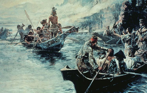
Scarcely a week went by without the expedition encountering the Indians who populated, controlled, and governed the North American West. Put simply, the expedition would have been a disaster were it not for the decisions those Indians made to provide supplies, food, geographical information, and, above all, safe passage.
In their expedition journals Lewis and Clark repeatedly stated that they met with Indians, informed them of the American claim to Louisiana, and watched as the Indians acknowledged that claim. In the written record Lewis and Clark overstated their own power and that of the United States. Indians hardly surrendered their own claims to sovereignty in the West. Instead, their reactions to Lewis and Clark ranged from bemused interest to outright hostility. The Lewis and Clark Expedition entered a world where Indians were clearly in charge. When the expedition returned, that state of affairs had not changed.
After the Expedition

The fates of the explorers following their return reflect life in the North American West at the turn of the nineteenth century. Most members of the expedition scattered into the West, seeking their fortunes in the highly competitive, often dangerous world of international and interracial commerce. Several came to a violent end, killed in negotiations gone badly.
Meriwether Lewis and William Clark found their lives transformed by the expedition. Jefferson soon promoted both men within the federal system. In 1807, Jefferson nominated Lewis to become governor of the Louisiana Territory. Although Lewis had been a successful expedition leader, he was a disastrous territorial governor, encountering intense criticism in Saint Louis and Washington, D.C., before committing suicide in 1809. In sharp contrast, Clark came out of Lewis’s shadow to become one of the most powerful officials in the American West. He eventually succeeded Lewis as territorial governor in 1813 and supervised the creation of the state of Missouri. He also served as a U.S. Indian agent from 1807 until his death in 1838. Both Lewis and Clark found their lives consumed by reshaping the West in the nineteenth century, as the Indians who controlled the West at the turn of the century slowly lost first their political autonomy and later their land to an increasingly powerful federal government.
If Lewis and Clark remain the most famous members of the expedition, the fates of two others who have more recently attracted attention reveal just as much about the West and the nation: Sacajawea, the Indian wife of Toussaint Charbonneau; and York, Clark’s slave. Clark repeatedly recorded Charbonneau’s poor treatment of Sacajawea, but like most women of her era she was bound by custom and law to obey her husband. She continued to travel with him along the trade routes of the upper Missouri, and eventually gave birth to another child. When she died remains uncertain, but the extant evidence suggests it was in 1812, when she may have been as young as twenty-four. Meanwhile, once the expedition was over, York repeatedly asked Clark for his freedom. Clark ignored the request for years. Like most white southerners who considered themselves fair masters, he found such requests to be both insolent and ungrateful. As with Sacajawea, the documentary record of York’s life is limited. Clark eventually did free York, but not for at least a decade after the expedition.
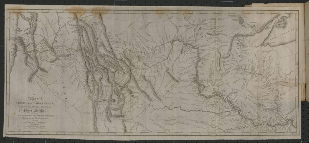
The written record of the expedition is equally illuminating. Jefferson had instructed Lewis to keep a detailed account. Six men, including Lewis and Clark, left journals that recorded the journey in varying degrees of detail. Lewis struggled without success to produce a single narrative from these sources. After he died, Clark inherited the task, working with editors to produce a book that was published in 1814. The two-volume work included a map of the North American West, originally drawn by Clark, that constituted a masterpiece in cartographic history, but the book soon went out of print. Interest in the Lewis and Clark Expedition was revived in the twentieth century not by that 1814 book, but rather by the numerous published editions of the original expedition journals. These journals continue to provide a window not only to a very different time, but also to a remarkable adventure.
Timeline
1783
Thomas Jefferson invites George Rogers Clark, William Clark’s older brother, who had commanded Virginia volunteers in the Northwest during the American Revolution, to lead an expedition into the North American West. Clark declines.
1785
In Paris, France, Thomas Jefferson suggests to John Ledyard, an American who served on Captain James Cook’s third voyage to the Pacific, that Ledyard travel overland through Russia, cross the Bering Strait, and then travel east from the Pacific across America. Ledyard agrees, but in 1788 is arrested en route by the Russians and deported.
1792
Thomas Jefferson, secretary of state under President George Washington, tries without success to encourage Philadelphia physician and botanist Dr. Moses Marshall to lead an exploratory expedition up the Missouri River.
1793
Thomas Jefferson urges members of the American Philosophical Society to sponsor André Michaux, a French botanist, who plans to travel across the American West. Michaux never crosses the Mississippi River, however.
1795
Meriwether Lewis and William Clark meet in the Northwest Territory while serving as officers in the U.S. Army. Clark, a captain, is Lieutenant Lewis’s commander.
1796
William Clark resigns from the U.S. Army to pursue business ventures with his family.
October 1, 1800
Representatives from Spain and the French Republic sign the Treaty of San Ildefonso, a secret agreement that transfers ownership of the colony of Louisiana from Spain to France. According to the treaty, France is allowed to postpone taking possession of Louisiana until such time as it sees fit. Until then, Spain maintains nominal control.
March 6, 1801
President Thomas Jefferson selects Meriwether Lewis, who has reached the rank of captain in the U.S. Army, to serve as his private secretary.
Spring 1803
President Thomas Jefferson invites Meriwether Lewis to command an expedition to explore the North American West. Lewis accepts and the two begin making preliminary plans. The Spanish, who have administrative control of the Louisiana Territory, inform the U.S. government that they will block any attempt to send an expedition to Louisiana.
January 18, 1803
President Thomas Jefferson sends a secret communication to Congress to request funding for an expedition to explore the North American West. Congress allocates $2,500 for the project.
April 30, 1803
In Paris, American diplomats Robert Livingston and James Monroe sign the Louisiana Purchase Treaty and two conventions with France. The United States agrees to pay to France $11.25 million and to forgive $3.75 million in French debts in exchange for 828,000 square miles of land west of the Mississippi River.
June 19, 1803
Meriwether Lewis invites William Clark to serve as co-commander of an expedition to explore the North American West; Clark immediately accepts. Their relative ranks will become a source of irritation for Clark when Secretary of War Henry Dearborn informs him that he can only re-enter the army as a lieutenant.
June 20, 1803
President Thomas Jefferson writes instructions to Meriwether Lewis, his private secretary and newly appointed leader of what will become known as the Lewis and Clark Expedition, regarding the expedition’s objectives.
Winter 1803—1804
Members of the Lewis and Clark Expedition make their winter encampment at Camp Dubois, on the eastern banks of the Mississippi River in what is now Illinois.
March 10, 1804
In Saint Louis, an official ceremony marks the formal transfer of ownership of the Louisiana Territory from France to the United States. Meriwether Lewis and William Clark are probably both in attendance.
May 1804—October 1804
The Lewis and Clark Expedition ascends the Missouri River.
May 14, 1804
The Lewis and Clark Expedition leaves its winter encampment at Camp Dubois; Meriwether Lewis and William Clark record the event as the official beginning of the expedition.
August 20, 1804
Sergeant Charles Floyd dies, probably as a result of appendicitis, near present-day Sioux City, Iowa. He is the only member of the expedition to die during the journey.
November 1804
The Lewis and Clark Expedition makes its winter encampment near the Mandan and Hidatsa villages near what is now Washburn, North Dakota. The expedition names the encampment Fort Mandan.
February 11, 1805
Jean Baptiste Charbonneau is born to Toussaint Charbonneau and Sacajawea at Fort Mandan, near what is now Washburn, North Dakota. Both parents are members of the Lewis and Clark Expedition.
April 1805—August 1805
The Lewis and Clark Expedition continues to ascend the Missouri River, eventually abandoning its canoes as it enters the Rocky Mountains.
April 7, 1805
A smaller expedition of thirty-three people (called “the permanent party”) leaves Fort Mandan. The others return to Saint Louis with plant and animal samples and a report by Meriwether Lewis for President Thomas Jefferson.
August 1805—November 1805
The Lewis and Clark Expedition locates the headwaters of the Columbia River, descends from the Rockies, and travels downstream to the Pacific.
August 12—13, 1805
Meriwether Lewis and his party reach the headwaters of the Missouri River, where Thomas Jefferson had believed the fabled Northwest Passage would be located, and cross the Continental Divide. Lewis determines that there is no water route connecting the Mississippi to the Pacific Ocean.
November 7, 1805
William Clark writes a journal entry describing his first sight of what he believes to be the Pacific Ocean, but what is, in fact, the Columbia estuary.
November 15, 1805
The Lewis and Clark Expedition reaches the Pacific Ocean.
November 1805—March 1806
The Lewis and Clark Expedition builds a winter encampment a few miles from present-day Astoria, Oregon. They name the camp Fort Clatsop.
March 23, 1806
The Lewis and Clark Expedition departs Fort Clatsop and begins its return journey to Saint Louis.
September 23, 1806
The Lewis and Clark Expedition reaches Saint Louis.
1807
President Thomas Jefferson appoints Meriwether Lewis governor of the Louisiana Territory and William Clark general in the territorial militia. Clark also becomes an Indian agent, a position he will hold until his death in 1838.
October 11, 1809
Meriwether Lewis commits suicide while traveling from Saint Louis to Washington, D.C., to defend his conduct as governor of the Louisiana Territory.
1813
President James Madison appoints William Clark governor of the newly formed Missouri Territory.
1814
History of the Expedition under the Command of Captains Lewis and Clark, to the Sources of the Missouri, Thence across the Rocky Mountains and down the River Columbia to the Pacific Ocean. Performed during the years 1804-5-6 …, the official narrative of the expedition edited by Nicholas Biddle and Paul Allen, is published.
1821
Missouri enters the union as a state. William Clark’s appointed position as territorial governor is eliminated, and he loses the gubernatorial election to Alexander McNair. Clark remains in Saint Louis and continues to work as an Indian agent.
September 1, 1838
William Clark dies in Saint Louis, Missouri, and is buried in the Bellefontaine Cemetery.
1905
Reuben Gold Thwaites, a Wisconsin-based writer and editor, publishes the first major collection of the original manuscript journals of the Lewis and Clark Expedition. In the century that follows, this seven-volume work will serve as the foundation for most editions of the journals.
1983—2001
The University of Nebraska Press publishes The Journals of the Lewis and Clark Expedition, a complete, definitive edition of the manuscript journals.
